07 Kasım 2026
açık


El Niño-driven storm burst sparks an unprecedented typhoon surge across East Asia, intensifying risks to communities, infrastructure and relief efforts.

East Asia has been battered by a series of unusually intense and erratic storms in recent months, driven by a powerful El Niño pattern that has amplified ocean heat and typhoon energy across the Pacific. The storms have killed dozens, disrupted air travel and damaged crops and infrastructure from the Philippines to Japan and China.
In October, Typhoon Champi approached Taiwan with sustained winds up to 295km/h, prompting near-total shutdowns across the island and widespread flight cancellations in Hong Kong, Taiwan and Japan. Although Champi did not make landfall in Taiwan, it caused severe coastal impacts in the region including submerged highways in the Philippines’ Batanes archipelago and power outages affecting about 15,000 homes in Okinawa, Japan.
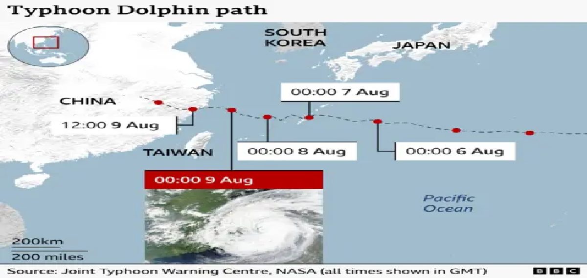
Earlier in the season, Japan experienced simultaneous approaches by Typhoon Mekkhala and Severe Tropical Storm Higos in June that forced one million people to evacuate. Tropical Storm Narra in July inundated villages along China’s Guangxi coast and displaced tens of thousands, while Super Typhoon Dolphin in August traversed the Pacific for 16 days before striking eastern China and causing heavy flooding and dozens of casualties. Typhoon Saudel later made landfall in three south-eastern Chinese cities over one week, disrupting transport and prompting evacuations.
The Pacific Ocean has warmed to record levels this season under El Niño, increasing the Accumulated Cyclone Energy metric for Southeast and East Asia to nearly double the 30-year average. Warmer seas are allowing storms to form further east and retain strength longer, intensifying their destructive potential. Sea surface temperatures in the equatorial Pacific rose to 4C above normal last month, surpassing the previous recorded peak from 1949 onward.
Manila-based climatologist Rafaela Jane Delfino and colleagues modelled higher temperature scenarios for the Philippines’ recent major storms and found that increased temperatures raised total accumulated rainfall by 26 percent, a worrying projection for a country already prone to floods from monsoon rains and frequent tropical storms. The intensified flooding in recent years has paralysed cities and fueled public protests over alleged corruption and weak investment in flood-control infrastructure.
Governments in the region are taking immediate precautions. Japan has urged citizens to stockpile food and secure outdoor items, China is upgrading warning and monitoring systems while identifying vulnerable areas, and the Philippines along with its Southeast Asian neighbours are supporting farmers and preparing for disruptions to rice production.
The escalation of storm intensity and frequency under a strong El Niño signals heightened acute risk across multiple sectors including transport, power, agriculture and housing. Record-high sea surface temperatures are enabling storms to become stronger and to form in different locations, complicating forecasting and evacuation planning. The modeled rise in accumulated rainfall highlights an elevated flood risk that can overwhelm existing urban drainage and flood-control systems, underscoring the need for targeted investments in early warning, resilient infrastructure and social protection to reduce casualty and economic impacts.